Luongo 2024, fig. 2
Related article: Luongo G. 2024, GIS integration of heterogeneous data for the archaeological topography of the ‘Acquedotto del Paradiso’, Syracuse, in R. Brancato, J. Bogdani, V. Vitale (eds.), Linking Pasts and Sharing Knowledge. Mapping Archaeological Heritage, Legacy Data Integration and Web Technologies for Modelling Historical Landscapes (Naples, 13th-14th November 2023), «Archeologia e Calcolatori», 35.2, 431-444 (https://doi.org/10.19282/ac.35.2.2024.45)
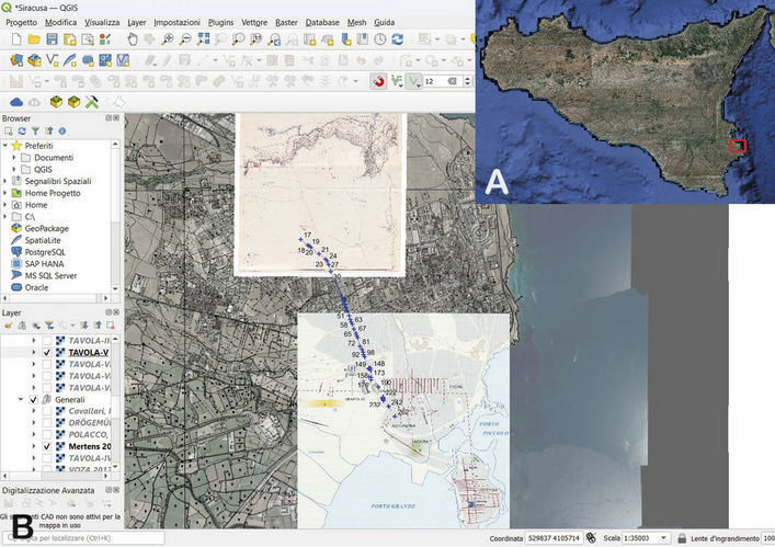
Caption
A) Orthophoto of Sicily. The red rectangle highlights the location of Syracuse on the East coast of the island; B) snapshoot of the QGIS software showing the Syracuse plateau area, illustrating the process of integrating and vectorizing the aqueduct path. In the background are Cavallari and Holm’s Tab. V, D. Mertens’ plan of Syracuse (Mertens 2006, 311, fig. 567), the CTR, and the orthophoto
Source
"Cavallari F.S., Holm A. 1883, Topografia archeologica di Siracusa, Palermo, Tipografia dello Statuto"; "Mertens D. 2006, Städte und Bauten der Westgriechen: Von der Kolonisationszeit bis zur Krise um 400 vor Christus, München, Hirmer."
Image preview
This website uses only technical cookies strictly necessary for its proper functioning. It doesn't perform any profiling and doesn't use third party cookies of any kind.
Read our privacy policy for additional information.
By clicking 'OK' or closing this banner you acknowledge having read this information and accept the website's contents.