Brancato et al. 2024, fig. 4
Related article: Brancato R., Ferrari V., Ditaranto I., Merola P., Rossi I. 2024, Investigating resilient Roman agricultural landscapes in southern Italy. An integrated and open IT approach to modeling centuriation, in R. Brancato, J. Bogdani, V. Vitale (eds.), Linking Pasts and Sharing Knowledge. Mapping Archaeological Heritage, Legacy Data Integration and Web Technologies for Modelling Historical Landscapes (Naples, 13th-14th November 2023), «Archeologia e Calcolatori», 35.2, 387-400 (https://doi.org/10.19282/ac.35.2.2024.41)
Caption
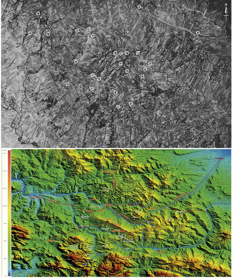
The territory of Irpinia (case study 2) in DEM (A) and historical aerial photograph (B) analised by the Archaeological Mapping Lab of ISPC-CNR (Lecce)
Source
DITARANTO I. 2017, Il contributo della fotografia aerea allo studio delle antiche divisioni agrarie in Irpinia Orientale, «Archeologia Aerea», 10, 146-153
Image preview
This website uses only technical cookies strictly necessary for its proper functioning. It doesn't perform any profiling and doesn't use third party cookies of any kind.
Read our privacy policy for additional information.
By clicking 'OK' or closing this banner you acknowledge having read this information and accept the website's contents.