Thiery, Schenk, Baars 2024, fig. 4
Related article: Thiery F., Schenk F., Baars S. 2024, Dealing with doubts: site georeferencing in archaeology and in the geosciences, in A. M. Marras, A. Palmisano, R. Leone, V. Messina (eds.), ArcheoFOSS 2023. Proceedings of the 17th International Conference on Open Software, Hardware, Processes, Data and Formats in Archaeological Research (Turin, 12-13 December 2023), «Archeologia e Calcolatori», 35.2, 97-106 (https://doi.org/10.19282/ac.35.2.2024.11)
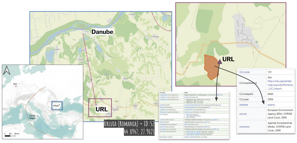
Caption
Left: schematic view of the distribution of the CI tephra in Europe (dashed orange line open to the E); Campi Flegrei as eruption site (orange dot; 40.8275° N, 14.1402° E); Urluia as find spot (blue dot/ rectangle; 44.0947° N, 27.9021° E); Eifel Lake sediment cores (red star); scale 1:20,000,000, EPSG: 3857, bounding box: −27,431.587, 3,598,880.852, 4,408,568.450, 7,668,605.656, created with QGIS, base map WorldTerrain by USGS, Esri, TANA, DeLorme, and NPS; middle: aerial line measurement between the possible location of Urluia (URL; purple rectangle) and the Danube. According to the literature, this is approx. 15 km, here 17.19 km; right: map showing the opencast mine (OSM way 84975654) and the possible Urluia coordinate point 44.0947 °N / 27.9021 °E as cisite_52 (purple rectangle) (left: F. Schenk, F. Thiery, https://codeberg.org/ResearchSquirrels/ci-map; middle/right: Open Street Map Contributors, ODbL, via OSM)
Source
https://codeberg.org/ResearchSquirrels/ci-map
Image preview
This website uses only technical cookies strictly necessary for its proper functioning. It doesn't perform any profiling and doesn't use third party cookies of any kind.
Read our privacy policy for additional information.
By clicking 'OK' or closing this banner you acknowledge having read this information and accept the website's contents.